North-West issued with yellow weather waring
Snowy showers and cold temperatures could lead to disruption across Lancashire.
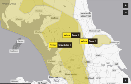
The warning for snow and ice is set from 8pm on Thursday to 11am on Friday.
A spokesperson for the Met Office said: "Frequent wintry showers arriving from the west during Thursday evening and overnight are likely to lead to a fresh covering of snow for areas above 200m (mainly around 2-5 cm, possibly as much as 10 cm over highest ground where showers are most frequent).”
Weather experts have predicted that the frequent sleet and snow showers may lead to some disruption with travel during Thursday night and Friday morning.
Areas including Clitheroe, Bacup, Blackburn and Burnley are covered by a second yellow weather warning for snow.
This warning is in place between 10am and 4pm today and predicts that snow may cause some travel disruption on higher routes in those areas.
Some areas of Blackpool and Preston are already seeing some light snow fall however, this could increase as we go into the evening and overnight.
The Met Office are also warning of icy patches that may accumulate where skies are clear overnight and have warned there may be risks of slipping on icy patches while travelling.
This comes after other areas of the North West have experienced severe weather this week, including flood alerts for the coast at North Morecambe Bay.
With bad weather picking up around the country Morecambe can expect a high tide as the day goes on due to a high amount of rain experienced at the start of this month.
The highest tide level is expected at 1.45pm today and flooding is possible for 2 hours either side of this time.
The high tides over the next couple of days are not expected to reach the flood alert level.
However, the government have closed flood gates in the area and are warning people to be careful along beaches, promenades, coastal footpaths and roads as large waves and sea spray could be dangerous.
Post a comment